Watershed Facts

Facts:
Crystal Lake Watershed
- Includes two communities and parts of six townships within Benzie County, MI
- Subwatershed of the Betsie River Watershed & the Lake Michigan Watershed
- Encompasses seventeen subwatersheds
- Watershed Area (Land + Water): 43.97 mi2 = 28,145 A = 113.88 km2
- Land Area: 28.58 mi2 = 18,291 A = 74.02 km2
- Perimeter: 44.650 mi = 236,000 ft = 71,900 km
Crystal Lake
- Lake Area: 9th largest of 11,000 MI inland lakes 15.40 mi2 = 9,854 A = 39.89 km2
- Ratio of (Land + Water) to Water = 2.856
- Ratio of Land to Water = 1.856
- Perimeter (unique due to historic drawdown) 20.838 mi = 110,025 ft
- Reach (Longest) 8.11 mi = 42,820.8 ft
- Depth (Avg) = Volume / Area): 70.70 ft = 21.55 m
- Depth (max): 165 ft = 50 m
- Volume: 741,366 Acre – ft = 0.242 x 10¹²gal = 0.220 mi3
- Elevation (IGLD 1985) 600.00 +/- 0.25 feet
- Center of Crystal Lake: 44.659167°N Lat: – 86.156389° W Long
Benzie County is 83rd in land area (321.3 4 mi2 ); 25th in Great Lakes water area (512.09 mi2 ); 24th in total water area (538.38 mi2 ); and 18th in inland lakes water area (26.29 mi2) of all Michigan Counties.
Crystal Lake spread evenly over all of Benzie County, would cover the surface to a depth of 44 inches – just about head high for a average 5 year old!
A faucet flowing at 10gal/min for 51 years would add 1 inch to Crystal Lake!
Lake Michigan contains the equivalent of 5,370 Crystal Lakes.
Crystal Lake is about “halfway” between “here” and “there”: It is “halfway” between the Equator and the North Pole. It is “halfway” between the NW corner of the UP and the SE corner of the LP of Michigan.
Crystal Lake (44° N Lat., – 86° W Lon.) is opposite a very remote spot – ( – 44° S Lat., +86° E Lon.) in the Indian Ocean between Australia and Antarctica.
The Aux bec Scies (the saw – billed duck, Mergus merganser) is the local namesake (Benzie, Betsie).
The Atlantic Smelt was planted in Crystal Lake in 1912 and spread through the western Great Lakes!
“Some consider blue ‘to be the color of pure water, whether liquid or solid.’ But, looking directly down into our waters from a boat, they are seen to be of very different colors. Walden (Crystal) is blue at one time and green at another, even from the same point of view. Lying between the earth and the heavens it partakes of the color of both.”
— Henry David Thoreau, Walden
The Lake Michigan Coastline of Northwest Lower Michigan has always captivated the imagination of all who “paddled by it” or “walked about it”. Beginning with explorations by Frs. Marquette and Charlevoix; land surveys by the Burt brothers, Alvin and Austin; geological surveys by Douglass Houghton, Henry Schoolcraft, and Alexander Winchell; the “Comedy” / “Tragedy” of Crystal Lake promoted by Archibald Jones; environmental studies by Henry Chandler Cowles, William James Beal, Warren Gookin Waterman, Irving D. Scott, Frank Taylor Leverett, James Lewis Calver; and Oren B. Evans, and the prose of William L. Case, Bruce Catton, and Earnest Hemingway, it has continued to the present day. Thoreau traveled on Lake Michigan near Crystal Lake, and “botani zed” at the Carp River (Leland), viewing the Manitou, Fox, and Beaver Islands.
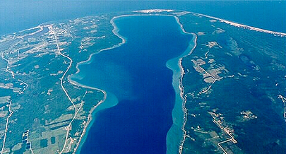
The Crystal Lake Watershed (Benzie County, NW Lower MI), bordering on the northeastern shore of Lake Michigan, contains diverse, hydrologically intertwined ecologies and unique environmental niches: active sand dunes, forested heights, wetlands, tributaries, and a large deep inland lake connected to Lake Michigan. It encompasses Crystal Lake, a very large body of pristine water, whose characteristics are described as: very transparent, deep, cold, hard, and oligotrophic. Crystal Lake is also known for its high – ridged vistas, lengthy sandy beach, mixed sandy and rocky nearshore, and deep marl bottom. The Crystal Lake Watershed and its 17 subwatersheds is nestled between the Platte River (N) and Betsie River (S) Watersheds. It is separated by high dunes from Lake Michigan and Point Betsie Lighthouse (W). The Sleeping Bear Dunes National Lakeshore is also contiguous (N). The Villages of Beulah and Benzonia are east and the City of Frankfort, former home of the Ann Arbor Carferries, is SW. The Wate rshed contains parts of three townships around the Lake (Benzonia, Crystal Lake, and Lake); and parts of three other townships (Homestead, Inland, and Weldon). Cold Creek is the largest of several small tributaries. Land and water uses are predominantly recreational with fruit farming and light manufacturing.
Crystal Lake is unique among large inland lakes. The “Tragedy” / “Comedy” of Crystal Lake was an epochal event that defined the future development of Benzie Co.1873, the Benzie Co.River Improvement Co. Archibald Jones, President) attempted to create two navigable slack – water canals connecting Crystal Lake with Platte Lake (N) and Betsie Lake (S) to convey settlers to the interior and products to market. The “Tragedy” was that t he capricious whitecaps of the Lake washed out a temporary dam and the canals never materialized. Crystal Lake lost ~ 2 5 % of its area and volume and its level was lowered by 20 feet. The “Comedy” was the creation of a 21 – mile sandy beach and prime recreational land around the Lake that now contains 1,100 cottages, resorts, and the county seat. The lake level is now controlled by dam at Outlet Creek that flows into the Betsie River, and onward into Betsie Bay and Lake Michigan.

 Protecting Crystal Lake Now for Generations to Come.
P.O. Box 89 • Beulah, MI 49617
info@crystallakewatershed.org
231.882.4001 Tel
The Crystal Lake Watershed Association (CLWA), is a non-profit (501c3) organization.
Photography: Jay Burt and Rick Cosaro
Site by: Rick Cosaro
